黄兰毅
黄兰毅 清华大学本科-环境设计 | 2019-2024 香港大学(研究生) | 2024-now 点击查看更多信息
清华大学 环境设计(本科) GPA 3.81(4.0) 课程:参数化设计(4.0)视觉语言(4.0)数字设计(4.0)环境物理(4.0)
2019.09 - 2024.06
香港大学 可持续建筑(硕士) GPA 3.72 Distinction 
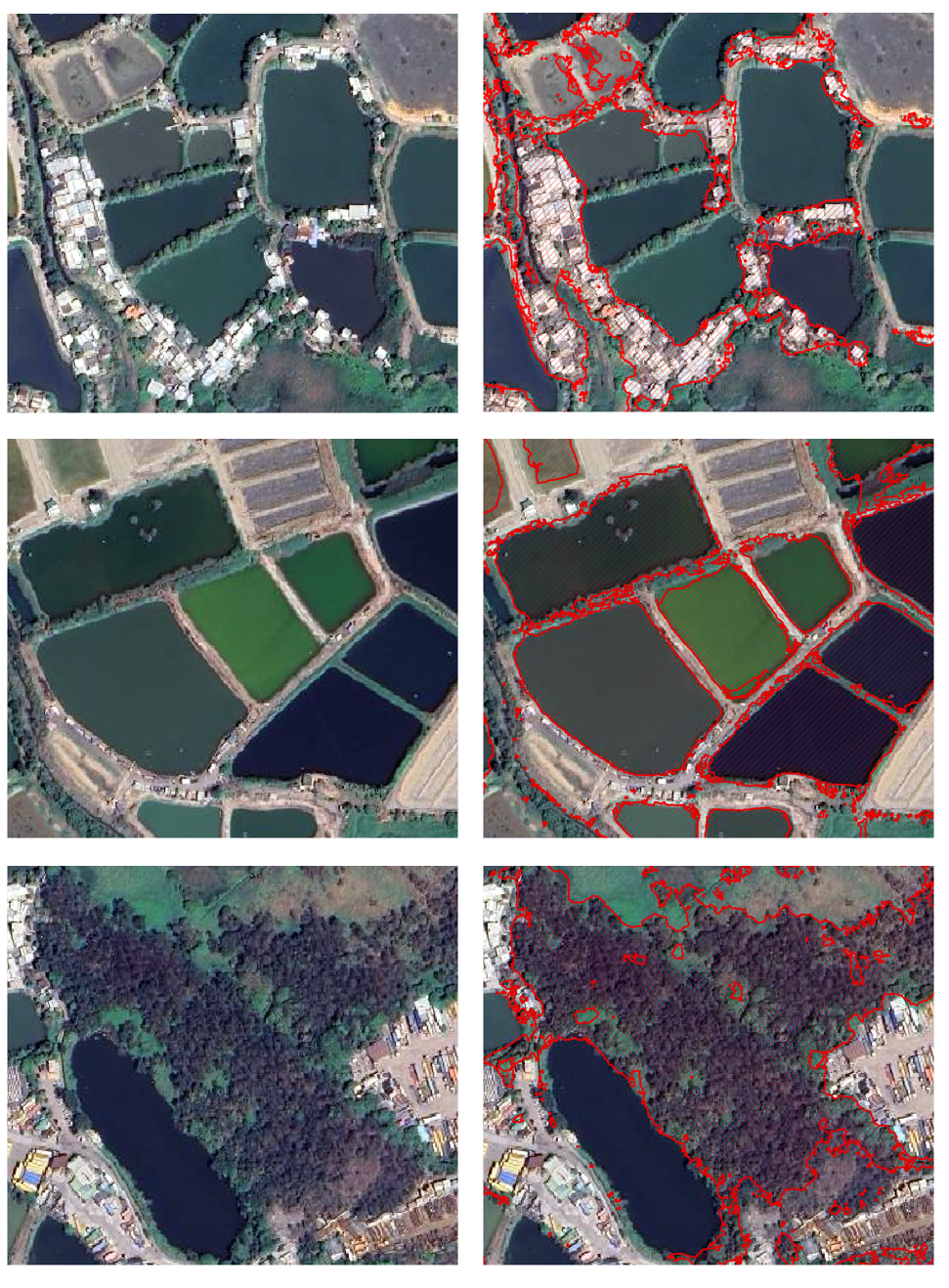
课程:GEE遥感信息(Java)GIS城市分析 ENVI-met微气候分析
2024.09 - 至今
日本东京大学 龍实验室空间信息学习实践
2024.12 - 2025.02
香港大学 建筑学院研究助理
2025.05 - 至今
Hello welcome
EMOPET
YIKE AI Customer Service


l设计并实现企业级B端AI客服管理系统,采用Win32与React技术栈构建桌面应用与千牛、微信、拼多多等多平台外部

l无缝对接开发智能会话引擎,集成自然语言处理模型,实现90%以上的常见客服场景自动化处理,提升客服效率处理物流信息实时查询、销售数据可视化分析、客户情绪动态监测等多维度功能模块

l创新性开发Win32句柄获取与AI决策引擎的交互系统,通过逆向工程技术实现AI对第三方应用的自动化操作和响应设计可配置化prompt系统,使非技术人员能便捷调整AI回复策略,降低运维成本

Slide 1
Slide 2
Slide 3
<
>
DL For Classification

To improve model convergence and performance on minority classes, I employed an exponential decay learning rate schedule, where the learning rate decreased by a factor of 0.1 every 30 epochs. This approach allowed the model to make large updates during early training while fine-tuning with smaller updates as training progressed, which was particularly beneficial for accurately classifying the underrepresented soil classes

Additionally, I incorporated a warmup period during the first 5 epochs, where the learning rate gradually increased from 1e-5 to the initial rate of 1e-3. This technique helped stabilize the early training phase and improved overall convergence, especially when dealing with the complex feature extraction required for distinguishing between spectrally similar land cover classes at 1-meter resolution.

For data augmentation, pixels with weak sun shadows such as water, plants, roads, and soil were enhanced using 60° rotation and horizontal flipping. However, for pixels with strong sun shadows such as buildings and trees, rotation and flipping decreased accuracy. This may be due to consistent shadow orientation in satellite maps taken at the same static time, and the 50ResNet101 model recognizing shadow features. Therefore, when creating satellite map mosaics, each year’s split map not only used the same month (September) but also maps with consistent sun shadow orientation when possible. Since road and soil classes had fewer training samples in the classification task, sample resampling was conducted by undersampling the majority classes while increasing the number of road and soil samples. Additionally, in remote sensing imagery land classification tasks, Focal Loss is a key technique for addressing class imbalance issues.

Happy Walker
滚动至顶部